


English version
Matsukawa Lake (Okuno Dam): Plum Blossoms Update + Easy Walk Routes (Map Included)
✅ What you’ll get from this post
- A quick “what’s blooming now” note (based on my visit)
- Two simple walking options (short / a bit longer)
- Where to look first so you don’t wander around
🧾 Quick table
- Time: Short stroll / longer lakeside walk (choose on the day)
- Cost: Free to enjoy the area (transportation is separate)
- Difficulty: Easy-to-moderate (watch slopes and cold weather)
- Highlights: ① Plum trees ② A dam-and-lake viewpoint ③ Quiet, nature-filled scenery
- Watch-outs: Cold shade / slippery ground after rain / keep an eye on daylight

- Map (open first)
- Bloom update: plums (as of my visit)
- What this place is like (in one minute)
- Best timing (general guide)
- 🧭 How to walk it (two simple options)
- ⚠️ Notes that make the day easier
- Who this is for / not for
- FAQ
- References
- 地図
- いま何が見られる?(梅の様子)
- いつ行く?(梅と桜の時期目安)
- 🧭 歩き方(案内図→短い回り方→少し長い回り方)
- ⚠️ 注意(当日ラクにするための3〜5点)
- FAQ
- 参考文献・出典
Map (open first)
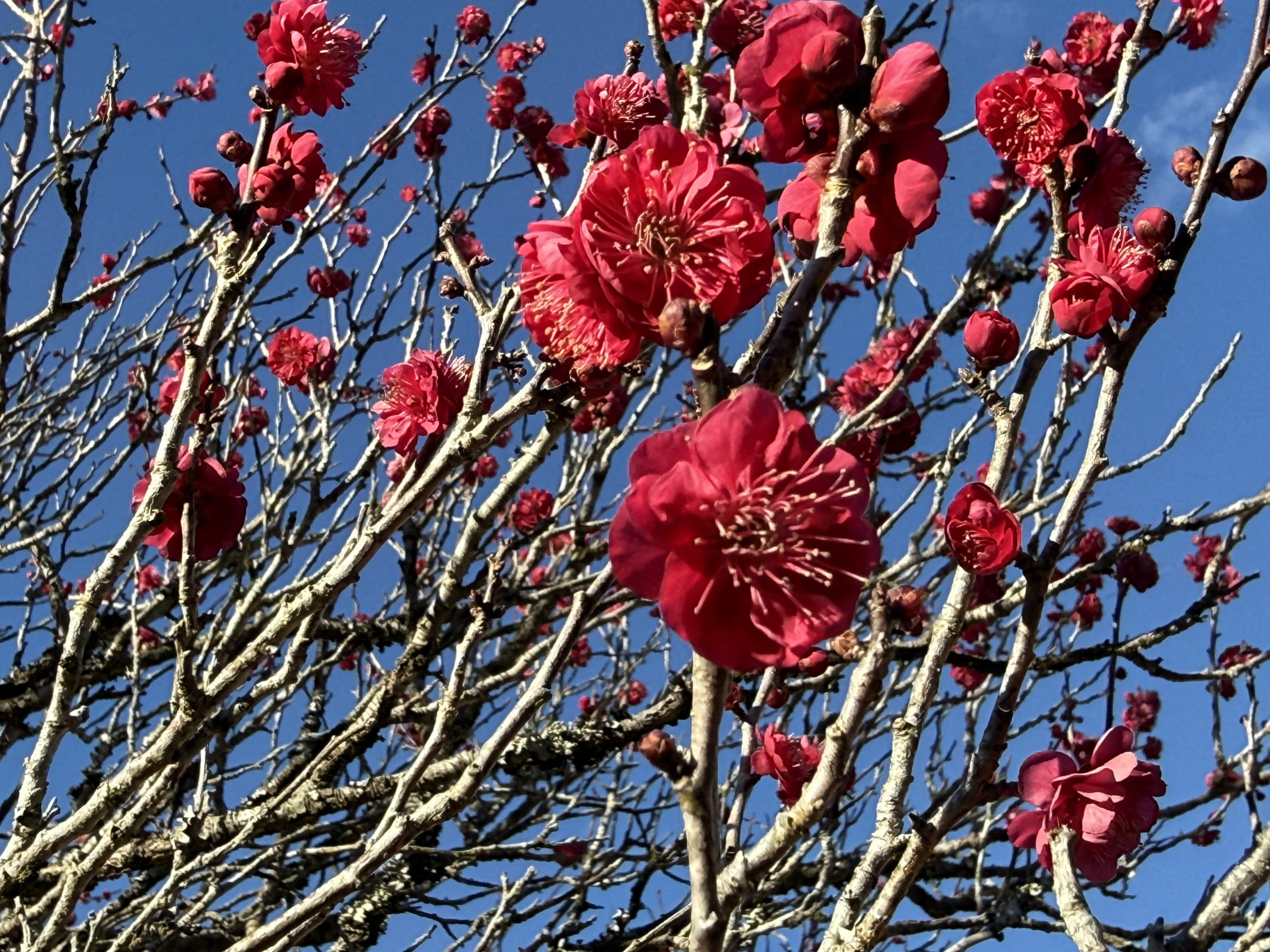
Bloom update: plums (as of my visit)
I came to see how the plum blossoms were doing. It wasn’t full bloom yet, but many buds were already swelling and some trees were clearly flowering.
On that day, it felt like the area was about 1–2 weeks away from its peak (weather can shift this earlier or later).
If you mainly want photos, check which section has more open flowers first, then decide your route.
(Photo: plum blossoms — close-up)
(Photo: a wider view of the plum area / slope)
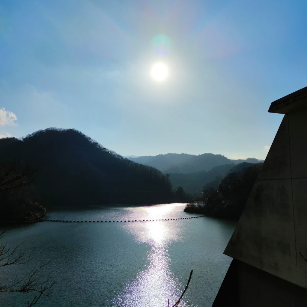
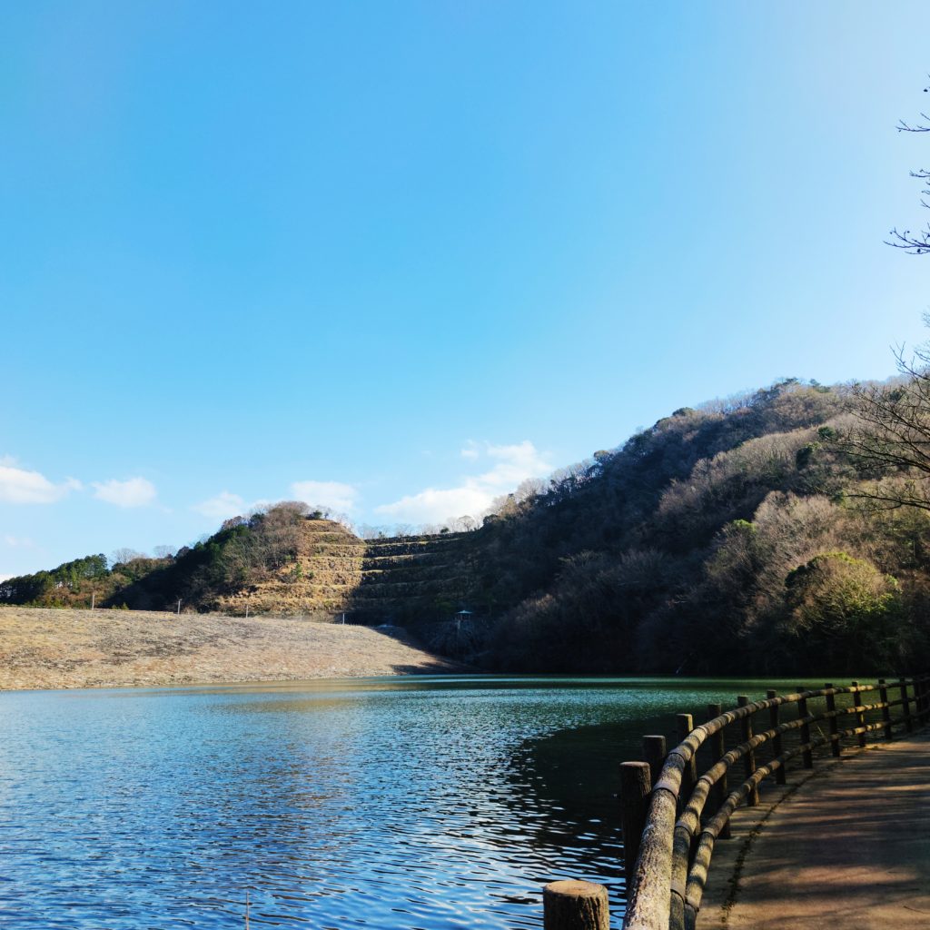
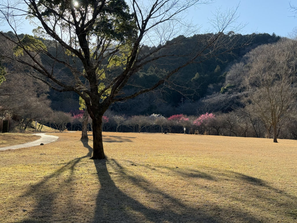
What this place is like (in one minute)
Matsukawa Lake is created by Okuno Dam, and the park area is surrounded by hills and forest. It’s an easy spot to slow down—especially when you combine flowers with a short walk.
There’s also a longer lakeside option if you feel like stretching your legs (see routes below).
(Photo: dam / lake view)
Best timing (general guide)
A local guide page introduces this rough seasonal flow around Okuno Dam / Matsukawa Lake:
- January: wintersweet (roubai)
- February: plum blossoms
- March: Kawazu-zakura (early cherry blossoms)
- April: Somei Yoshino (standard cherry blossoms)
Year-to-year timing changes, so use this as a guide and rely on recent updates when planning.
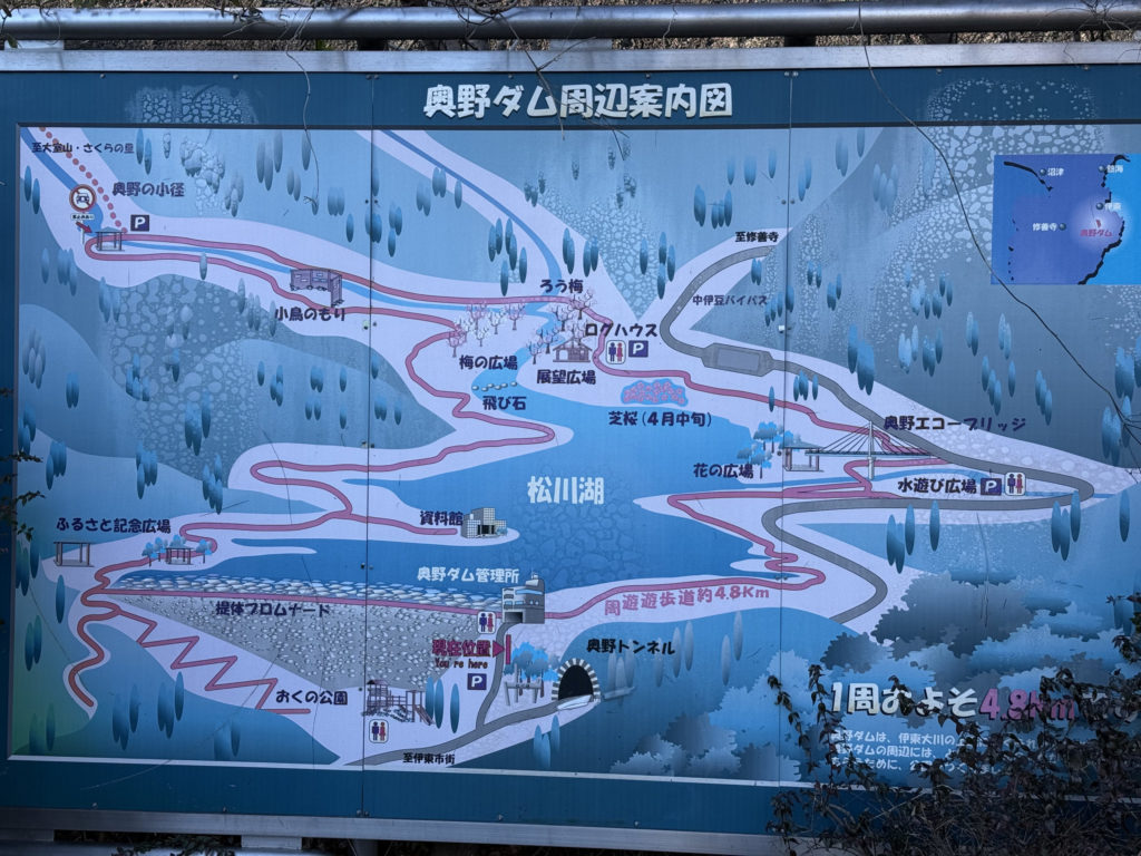
(Photo: signboard / park map, if you have it)
🧭 How to walk it (two simple options)
Option 1: Short and easy (flowers-first)
This is for “I just want plums + a nice view.”
- Parking area → head toward the plum spot first
- Take photos → move to an open viewpoint area
- Return the same way
Tip: If it’s windy or cold, do the photo part early and keep the viewpoint stop short.
Option 2: A bit longer (add more lakeside scenery)
If you have time, add extra lakeside walking after the plum area.
- Parking area → plum spot → viewpoint → continue along the lakeside path → return
This option works well when the ground is dry and you still have daylight.
⚠️ Notes that make the day easier
- If the ground is wet, don’t push into slippery slopes. Take photos from stable footing.
- Shade stays cold. Bring one layer you can put on/off.
- Decide a “turn-back time.” Photos and footing get harder late in the day.
Who this is for / not for
Good fit if you:
- Want a low-stress flower stop in Ito (not a crowded “must-see” spot)
- Prefer walking at your own pace with space around you
Maybe skip if you:
- Need “guaranteed full bloom” (flowers vary by weather)
Alternative idea: If plums are still early, plan for the cherry season next (Kawazu-zakura → Somei Yoshino).
FAQ
Q1. Is it worth going even if it’s not full bloom?
A. If you’re okay with “some trees open, others still in bud,” it’s still a pleasant walk—especially with the dam and lake scenery.
Q2. How long should I budget?
A. For photos + a short stroll, keep it simple. If you extend along the lakeside paths, allow extra time.
Q3. What should I bring in winter?
A. A warm layer for shade, comfortable shoes with grip, and something to keep hands warm if you’ll stop for photos.
References
- Ito Marine Town: “Okuno Dam (Matsukawa Lake)” (typical bloom months & basic info)
https://ito-marinetown.co.jp/sitescene/izu/okunodam/ - Rakuyu (older related post): “Okuno Dam & Matsukawa Lake cycling / plum area notes”
https://rakuyu.co/2020/01/26/post-4085/
Last updated: 2026-01-24 (edit if your visit date differs)
✅ この記事で分かること
- 松川湖(奥野ダム)周辺で、梅がどんな感じで咲いていたか
- 案内図を使った「短い回り方」と「少し長い回り方」
- 次に来る花(河津桜・ソメイヨシノ)の時期目安
🧾 早見表
- 所要:短い回り方/湖を一周(約4.8km)[2][3]
- コスト:駐車場は無料と紹介[2]
- 難易度:遊歩道が整備されている(斜面と冷え込みは注意)
- 見どころ:①梅のアップで撮れる ②広場から梅林を眺められる ③案内図で花の場所が分かる
- 注意:①日陰は体が冷えやすい ②斜面は靴で差が出る ③夕方は足元が見えにくくなる
地図
いま何が見られる?(梅の様子)
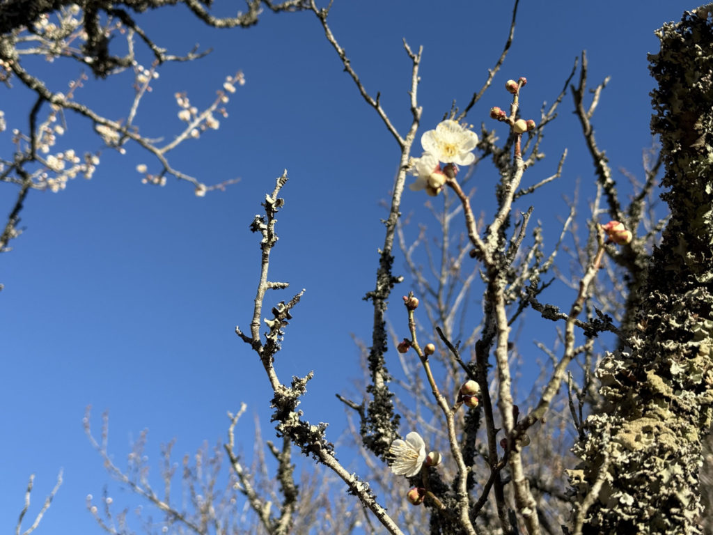
満開ではなく、つぼみが多い枝もありました。咲いている木はしっかり色が出ていて、近くで見ると撮りやすいです。
遠くから眺めると、白っぽい花とピンクの花が混じって見える区画がありました。先に「どの斜面が咲いているか」を見てから寄ると、歩く距離が読みやすいです。
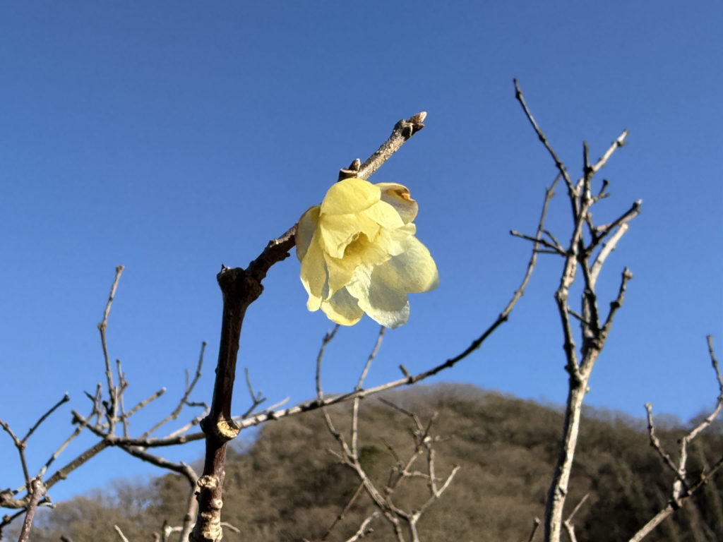
黄色い花も点々と見えました。花の名前は現地表示を見て確かめるのが確実です。
いつ行く?(梅と桜の時期目安)
目安として、松川湖周辺は「2月に梅、3月に河津桜、4月にソメイヨシノ」と紹介されています[2]。年によって前後するので、出発前に最新の開花情報を一度見ておくと安心です。
桜については、静岡県の案内で「カワヅザクラ(1月下旬)、ソメイヨシノ(3月下旬)、オオシマザクラ(4月上旬)」の目安が示されています[1]。
梅のあとに桜が続く時期は、同じ散歩でも見える色が変わります。[1][2]
🧭 歩き方(案内図→短い回り方→少し長い回り方)
まずは現地の案内板を撮っておくと、歩き方をその場で決められます。案内板には「梅の広場」「花の広場」「水遊び広場」などの表示があり、「周遊遊歩道 約4.8km」と書かれていました。
短い回り方(花だけ見たい)
- 駐車場付近(ログハウスP) → 展望広場 → 梅の広場 → 戻る
- 途中で「咲いている木が多い区画」だけ寄って戻る
⚠️ 注意(当日ラクにするための3〜5点)
- 日陰は体が冷えやすいので、上着は脱ぎ着できるものが便利です。
- 斜面や芝生は足元が滑ることがあります。靴で歩きやすさが変わります。
- 夕方は足元が見えにくくなります。撮影をするなら早めが動きやすいです。
- 駐車場・トイレがあると案内されています[1]。場所は案内図で先に押さえると移動が短くなります。
FAQ
Q1. 駐車場とトイレはありますか?
A. あります[1]
Q2. バスで行けますか?
A. 静岡県の案内では、JR伊東駅からバスで「城の平」下車、徒歩移動の目安が示されています[1]。本数や時刻は変わるので当日に確認してください。
Q3. いつが見頃ですか?
A. 目安として「2月が梅」と紹介されています[2]。年によって前後するので、直前の開花情報を見てから決めるのが確実です。
参考文献・出典
- [1] 静岡県. 松川湖(奥野ダム). 静岡県公式ホームページ. https://www.pref.shizuoka.jp/kurashikankyo/shizenkankyo/sakura/1057743/1058518/1058522.html
- [2] 道の駅 伊東マリンタウン. 松川湖畔展望広場(奥野ダム). https://ito-marinetown.co.jp/sitescene/izu/okunodam/
- [3] 伊豆・伊東観光ガイド(itospa.com). 奥野ダムと松川湖. https://itospa.com/spot/index_1_2_1_____0_1.html
(更新日:2026-01-24)

コメント